Our Notes & References
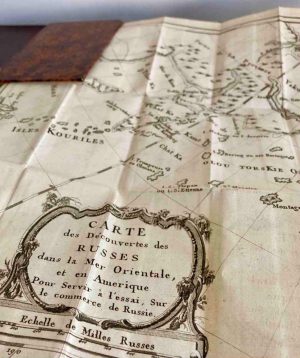
Charming and very rare pocket atlas of the Russian empire, its regions and its 1000-year expansion, in 802-1800, containing in particular the maps of Alaska and Siberia. In pleasant condition with original hand-colour.
The noted professor and publisher Ivan Einerling (d. 1854) ran a boarding school for male students in the 1830s and 40s in St Petersburg and taught French and geography. Einerling sought to introduce visual aids to the education of young people and to enrich children’s libraries, then still very poor, with useful and at the same time interesting books. As a result, he compiled, translated, adapted and published at his own expense more than 50 different textbooks and classics, directly linked to his pedagogical work.
His Uchebnyi atlas shows in detail the provinces of the Russian Empire in the early 19th century – consisting of 65 maps with original hand-colour, including in particular a rather detailed map of ‘Russian America’ with the North-West Passage and many islands, one of the Caucasus, some maps of the Kingdom of Poland at different times, two larger folding maps of Asian-Siberian and European parts of Russia, and a number of historical maps showing the expansion of territories of ancient Rus and Russia from 802 up to 1800.
Einerling’s geographic manual seems to be most likely based on Ivan Akhmatov’s (1766-1829) first historical Russian atlas, prepared for Nikolai Karamzin’s celebrated History of Russian State and published posthumously in 1831. Akhmatov’s atlas finished on Ivan III’s (1440-1505) Russia and was later augmented and published by Einerling himself in a new edition of Karamzin’s History in 1845. Originally, Karamzin’s work with the atlas was published by Smirdin – but the latter faced financial difficulties by the late 1830s and ceded the publication to Einerling. It seems that Einerling published a small amount of this Uchebnyi atlas for his students while preparing the larger publication for Karamzin’s new edition.
Absent from all main bibliographies, the atlas is mentioned in the list of recent publications in Pushkin’s Sovremennik in 1838, where it is described as “convenient and useful”.
Interestingly, this copy was presented to Apolon Sapozhnikov, a pupil of the first grade “for his successes and good manners” – possibly by Einerling himself at his school.
First edition, of great rarity: we could not find any copies in auctions nor in libraries. Absent from the Russian National Library (St. Petersburg) and from the State Library (Moscow, which has a similar title, with fewer maps and published in 1862). WorldCat doesn’t show any physical result (just one, apparently digital, result in a Moscow institution for a “children” atlas).
Provenance
Apolon Sapozhnikov (lettering in blind to upper cover “Za uspekhi i blagonravie ucheniku I classa Apolonu Sapozhnikovu. 1844” [“To Apolon Sapozhnikov, Grade I pupil, for his achievements and good behaviour”]).
Bibliography
Tolstiakov, A.P. Izdatel I. F. Einerling. Biograficheskaia spravka. (online)
Russkii biograficheskii slovar Polovtseva. T. 24, 1912, pp. 197-198. (online)
Sokolov V. I., Italianskaia ili opytnaia bukhgalteria. // Vestnik SPbGU. Economika, 2018, T. 34, vyp. 4.
Physical Description
Sixteenmo (14.5 x 11 cm). Title, dedication to Prince Nikolai Borisovich Iusupov, 63 copper engraved maps, including 11 folding, 2 large folding maps of Asian and European parts of Russia, and [4] pp. advertisement; all maps outlined in contemporary colour.
Binding
Contemporary calf, title and fleurons in blind to spine, ornamental frame in blind on boards, lettering in blind on upper board.
Condition
Hinges weak, rubbed, spine chipped at extremities with a couple wormholes, binding stained; several maps at rear with margins slightly chipped, some soiling and staining throughout, the last several maps repaired on folds, one map’s edges chipped.


![Image for ANGLIIA [England]. First edition, very rare. Moscow, 1914. #2](https://www.pyrarebooks.com/wp-content/uploads/2026/05/3367_1-300x405.jpg)