Our Notes & References
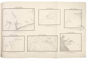
A rare scientific work describing the preparation, method and results of an expedition to Central Asia tasked with establishing the level difference between the Aral and Caspian seas – the Aral sea was found 74 meters higher. Printed in relatively large format, it includes a large and detailed map of the territory between both internal seas, which nowadays is split between Kazakhstan and Uzbekistan. Maps of this area were not commonly found before the 20th century, especially in such large scale.
Other plates include a representation of the (Swiss) instruments used for the work, as well as various “permanent landmarks” used for measuring, mostly stones on wells or tombs.
Descending from a French Protestant family which settled in Kyiv, Aleksey Tillo (1839–1900) became an officer in the Russian army and a prominent Russian geographer, land surveyor and cartographer, interested in geography, terrestrial magnetism and meteorology among other themes. He published many works and is known to have coined the term ‘Central Russian Upland’.
Scarce: we could not find any other example at auction (including in Russia) in recent decades. WorldCat shows only 3 holdings in the USA (NYPL, Drexel and Wisconsin-Milwaukee), and 3 locations in Europe (Germany and Sweden).
Provenance
Crossed-over gift inscription to title; Biblioteka Imp. Geograf. Obshchestva (Library of the Imperial Geographical Society; blue ink stamp dated 28 November 1883 to wrappers, title and maps along with red deaccession stamp across, shelf numbers in dark ink to upper wrapper and spine label).
Physical Description
Large 4to (34 x 25 cm). 40 incl. title and t.o.c. leaf, [2] pp., large folding map, 6 smaller maps on one folding sheet, 2 lith. plates incl. one folding, all plates by Ilin.
Binding
Original publisher’s printed wrappers.
Condition
Wrappers a bit soiled and marked, with pencil inscriptions in Swedish, edges a bit frayed, one closed tear; marginal worming and small marginal closed tear to title and first leaf, minor spotting or handling creases.