Our Notes & References
“The first fundamental monograph on the geography, history and ethonography of the Kazakh people” (Kuanyshbaev & Rubinshtein): attractive example of the scarce first French edition, with plates and an important folding map of the region. These illustrations are the same as the first edition, published in Russian in only 400 copies just 8 years earlier (the map was re-engraved for this edition).
One of the founders of the Russian Geographical Society, Liovshin (1798-1879) based his work on the material collected during his service at the Orenburg Border Commission in 1820-22. The author was much praised for his ability to combine scientific research with knowledge acquired directly from interaction with local people. Shokan Valikhanov (1835-65), another great Kazakh historian whose monument stands today in front of the Kazakhstan Academy of Sciences in Almaty, called him the “Herodot of the Kazakh steppes”.
Liovshin’s groundbreaking work, first published partially by Pushkin himself, covers the geography, history and ethnicity of nowadays Kazakhstan, Kyrgyzstan and Tadjikistan. Thanks to the extent of the work, its detailed researches and its structured method, it became the first comprehensive overview of the socio-political and ethnic Kazakh system. Liovshin extensively analysed most of the available Russian and foreign sources containing ethno-historical records of Kazakhs, and used in his work only information the validity of which he could prove.
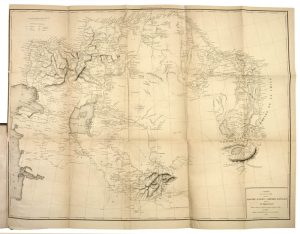
A significant asset of Liovshin’s work was his map too, here present as a large folding ‘Carte du pays occupé par les Kirghiz-Kazaks ou Kirghiz-Kaïssaks et du Turkestan’: it is a rare depiction of land included between, in the North, Orenburg and Omsk and, in the South Bukhara and Samarkand.
Still in Soviet times, researchers such as the Kazakh ethnologist Edige Masanov (1926-65) considered it to be the most fundamental source for research of the Kazakh ethnography and in many cases the only one.
Bibliography
Obolianinov, Katalog Russkikh illustrirovannykh izdaniy 1725 – 1860 (Moscow, 1914), 1461; Gennadi, Russkie Knizhniye redkosti (St. Petersburg, 1872), 157; Ostroglazov 224 (with detailed description of the contents); С. Куанышбаев and Е.Б. Рубинштейн, Министерство образования и науки Республики Казахстан, in Учебно – методический комплекс по дисциплине «Источниковедение истории Казахстана, 2010.
Physical Description
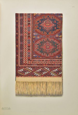
Tall 8vo (24 x 15.8 cm). Half-title, title, dedication leaf, vi, 514, [2]pp., with ‘atlas’ title lithographed by Coulon, 10 lithographed plates and a large folding map.
Binding
Contemporary calf over marbled boards, gilt lettering to spine.
Condition
Binding minimally rubbed or scratched; text with some occasional foxing or browning, marginal tears not affecting text, neat repairs to the folds of map.


![Image for IAKINF [BICHURIN]. Zapiski o Mongolii. Skt. Peterburg, 1828. #2](https://www.pyrarebooks.com/wp-content/uploads/2023/03/607_1-300x240.jpg)